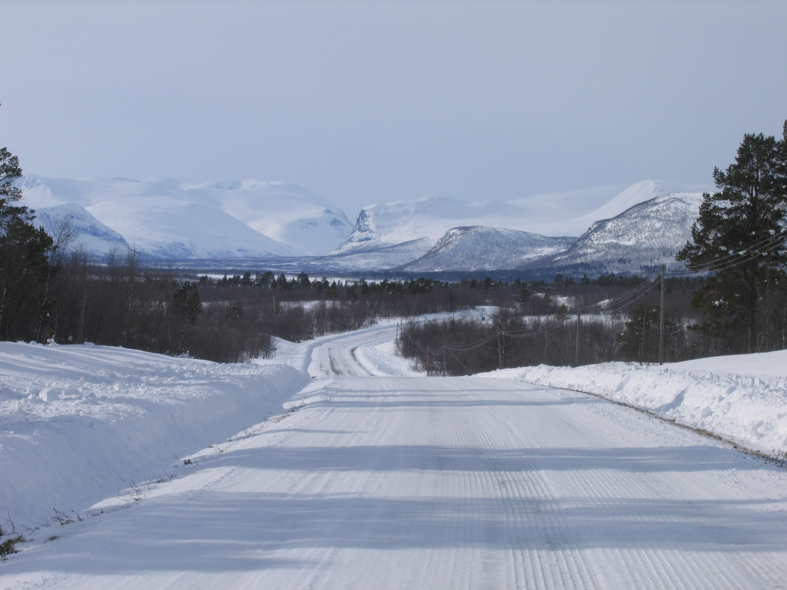
Past the road to Kalixfors, then Kalixforsbron. Proceeding to Kaalasjärvi, Jänkänalusta, Holmajärvi. Small sami villages. In total, maybe 150 people live in this valley, 50km long, in less than ten villages. Every five to ten kilometers, a sign giving the distance left to Nikkaluokta. 42km. 35km. 30km. Over halfway there. The bus passes by. I sit at the side of the road eating an apple. The closer I get to Nikkaluokta, the emptier the road. And the icier. At the last 10km, Pirttivuopio - Ylipää - Nikkaluokta, I have the road all for myself. I hear nothing. No cars. No birds. No snowscooters. No dogs. No planes. Just complete silence.
I arrive a lot earlier than I had expected, around two 'o clock. Three hours in Nikkaluokta until the bus leaves. Unfortunately, clouds against the mountains.
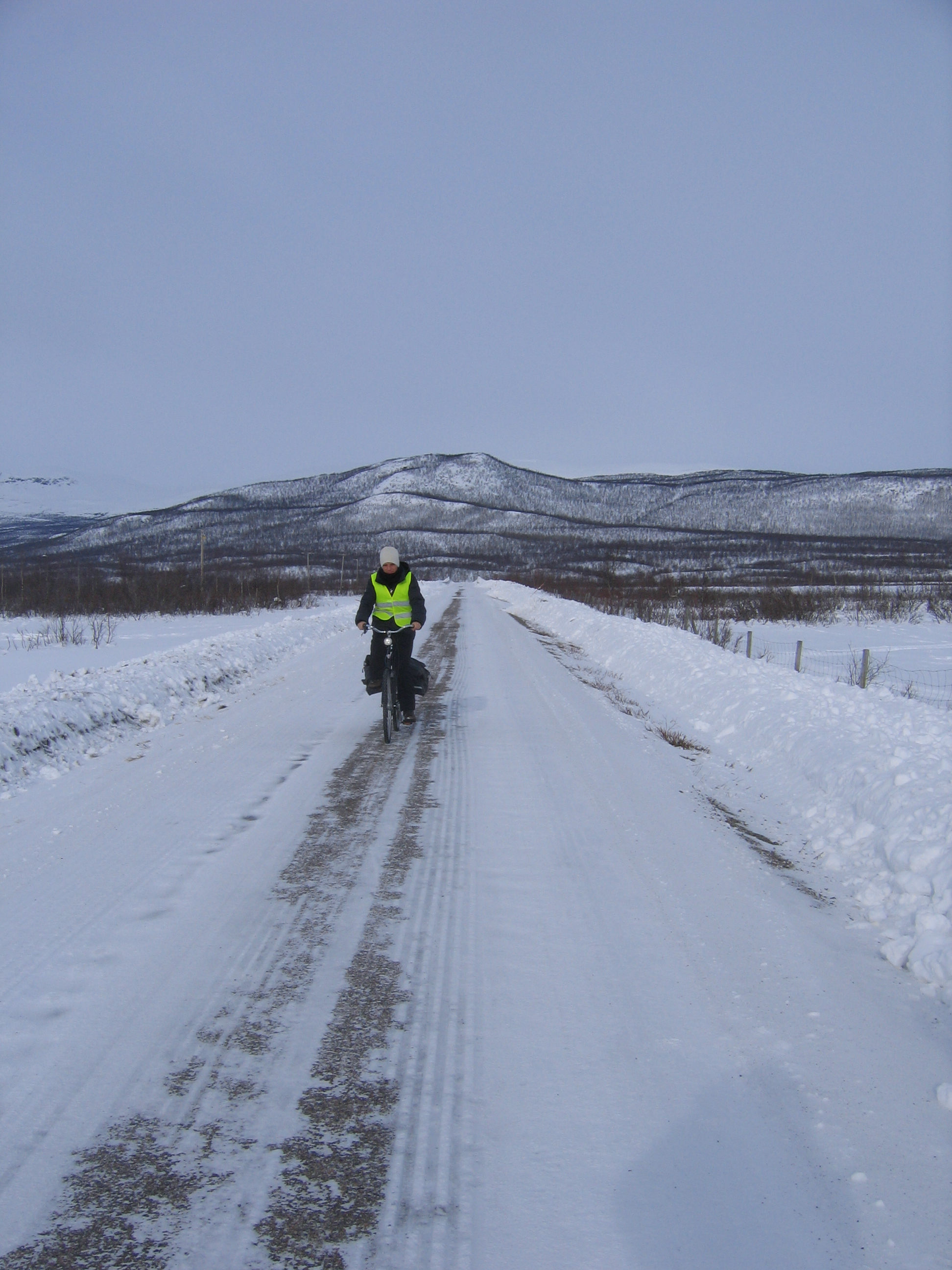
When I arrive in Nikkaluokta, an older couple makes a photograph of me. I ask them if they want to make a photograph of me with my camera, and they agree, so I cycle a bit back and come cycling toward them again. They are a Swiss couple on holiday here. They have seen me from the bus. They ask if it isn't lonely to cycle there. I like that, I answer. Where am I from. From the Netherlands. Yes, cycling. Yes.
When they speak with each other, it is more difficult for me to understand it than Swedish.
Nikkaluokta is a beautiful place. Pictures here. But the place itself is boring. Three hours is too much.
Wednesday morning. I have appointed with three other students to go to Å i Lofoten by train and bus, and go camping there. The first one should join the morning train (7:36) with me in Kiruna, the others should join in Abisko Turiststation. I arrive at the railway station ten minutes before and take a seat. I stand outside to wait for the other student. He isn't coming. The train leaves and he still isn't there. I try to phone him but I can't. I don't have his Swedish number. And my battery is empty. The battery readout for my phone is erronuous.
In Abisko Turiststation, the two others do not enter the train either. They went skiing and camping in the mountains. Without proper equipment and with limited experience. I hope they're allright. I can't reach them. No battery. This is getting odd. I am alone now. But it's such a beautiful day, I will go nevertheless.
In Narvik, I have about five hours, from 10:20 to 15:10. I get a city plan at the tourist office and walk to the bus station first, to see where I need to take the bus later today. I fail to find the direct route and end up walking there in a long, roundabout way, but at least now I have found it. It's at the bottom of the AMFI shopping center, a four storey shopping center with lots of stores. Narvik seems so much bigger than Kiruna. The town has even less inhabitants than Kiruna, just 14,000, but Kiruna is the end of the world and Narvik is a center. You pass by if you go from southern or centrtal Norway to northern Norway. You pass by on the way to Vesterålen or Lofoten. On the way to the mountains of Kiruna. And the surroundings are densely populated, certainly compared to the surroundings of Kiruna. Outside Kiruna, a few thousand people live in 22,000 km². In the coastal part of Nordland, around 240,000 people live on a similar surface area. Narvik is the 2nd biggest town in this area. It's a beautiful place.
I go to the bookshop to buy some maps of the area. In the bus, I want to see where I am. Exactly, not approximately. So I buy map 1431 IV Narvik, Turkart Lofoten and Turkart Vesterålen - Hinnøya. And in summer I want to go north of Torneträsk, so I also buy Turkart Bardu.
The bus leaves at 15:10. It will be a long bus ride: until 22:45. But a lot to see. From Narvik to Bjerkvik, along the fjord. 36km over the road, but only 14km through the air. Over Rombaksbrua and along the junction with the E10. At the junction it says Luleå to the right. It doesn't say the road goes to Kiruna. Kiruna is not important enough. Or maybe because Luleå is the end of the road, because the other way it says Å, which is just a small village. But it's the other end of the road. My destination. Straight ahead it says Alta 511 km. Southward it says Trondheim 903 km. Norwegians know what distances are.
After Bjerkvik, where the E6 northward and the E10 leave again, having been combined since the junction with the road from Kiruna, the road proceeds to the airport at Evenes. A bit inland, then a bit along a fjord again and a bit inland. I've been on this part of the road before. In october 2005, I went to Lødingen with three French students. And in January 2007, I wook the airport bus from Evenes to Narvik. In the dark. This is the first time I can actually see what it looks like in winter. There is a big difference in snow coverage on different sides of the fjords. The northern side of the fjord, a south slope, has considerably less snow than the southern side, north slope. It's quite obvious, but I hadn't thought of it.
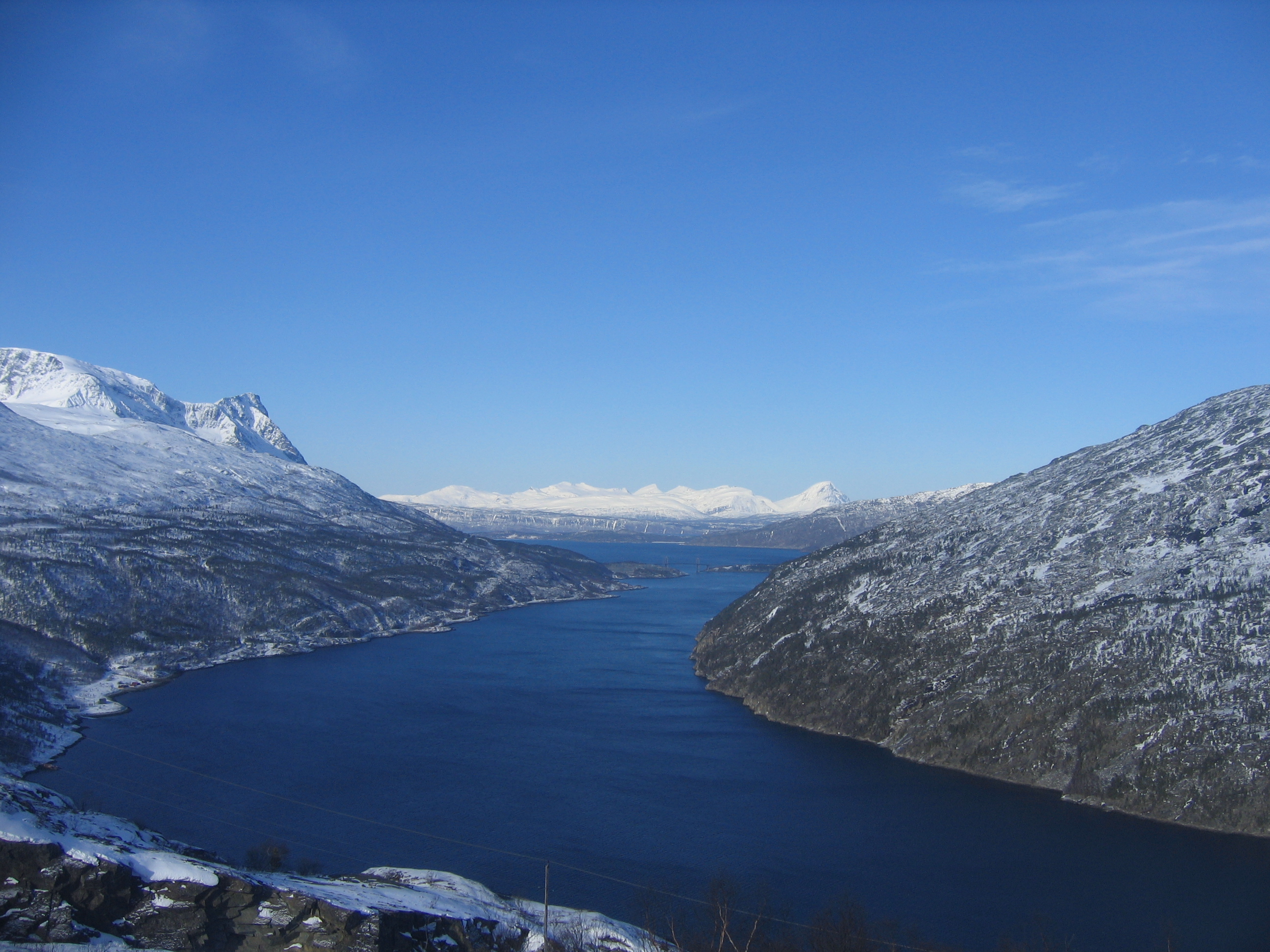
From Evenes we drive north along the Tjeldsund. The Tjeldsund seperates the mainland from the first island, Hinnøya, Norways biggest island. It also seperates the area where places have names in Norwegian and Sami from the area where the names are only in Sami. Is one strait, less than 1 km wide, enough to keep the Sami from crossing? Do the Sami not have boats? It's interesting. The island Hinnøya itself has a Sami name - Iinnasuolu - but that' the only one. They can name that island while standing on the mainland. We cross the Tjeldsund bridge at around 16:50, and leave mainland Scandinavia.
From here we drive south to Lødingen. Lødingen is a special place for me. It is located beautifully on a southern tip at Hinnøya, where the Tjeldsund and Ofotfjorden combine with Vestfjorden. Southward one can see mainland Norway with Tysfjorden. It is a beautiful place. Over the road, it's 147 km from Narvik. Through the air it's less than 60.
From Lødingen, the area is new for me. It's March so it's still light for some hours even though it is the late afternoon. From Gullesfjordbotn, at the southern tip of Gullesfjorden, a fjord going so far inland that the end is frozen, the bus enters a road that is not yet on the map: the road was opened 1 December 2007 and reduces the travel time to Å considerably. 50 km shorter and no more ferries, just tunnels and bridges. Inland there is a lot of snow. 5 km inland, 100 meter up, and it's 40cm rather than 5 cm. Still a lot less than the more than 100cm in Kiruna.
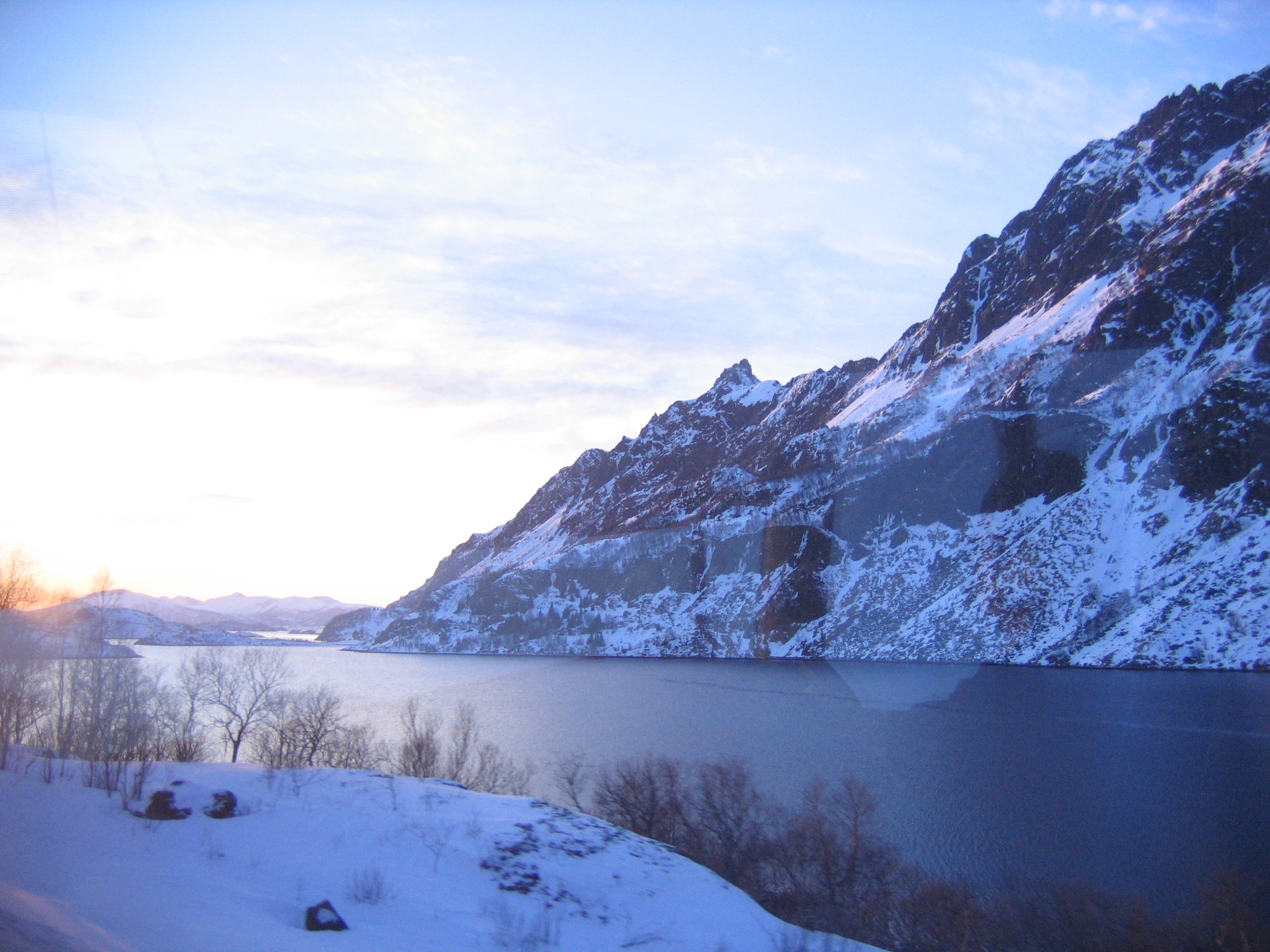
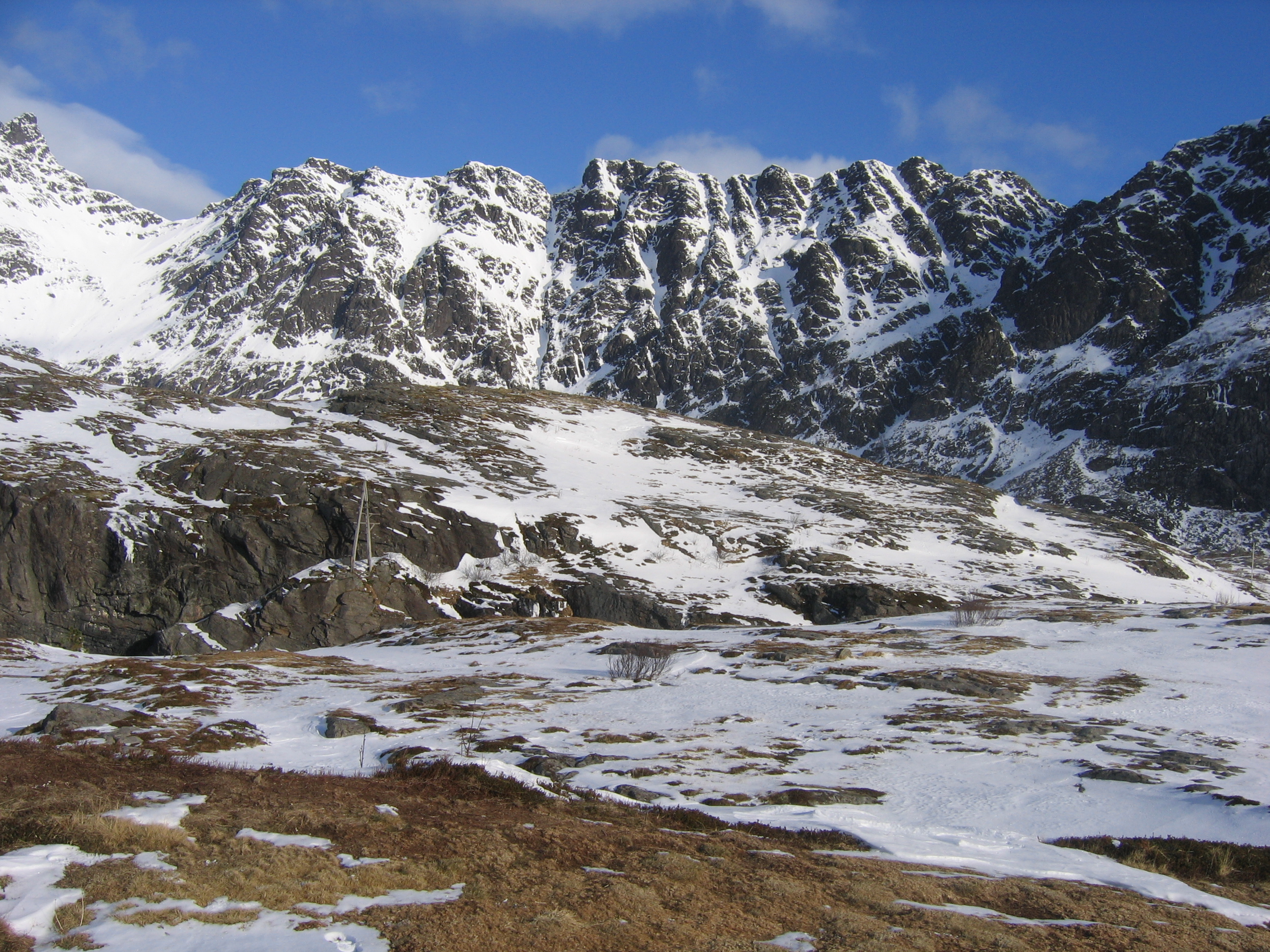
At Hanøyvika we cross Raftsundet with a bridge, from Hinnøya to Austvågøya. We are now officially in Lofoten. And the mountains get steeper and steeper and more and more impressive. We proceed along Hadselfjorden on the northern side of Austvågøya. From here, there is a view of the open sea westward. On the other side is Greenland. The sun is setting and it is a nice sunset. It's around 18:30 now; I have been in the bus for over three hours already, but in time I'm not even halfway there.
I am surprised that there is still quite some snow here. I had expected the climate to be a lot milder on the islands, and the snow to have melted. But it has been cold and wet recently. Easterly winds. And thus there is snow, and there probably will be all the way to Å. That will be interesting, putting up my tent in the snow in the dark. Without headlights. The students who didn't turn up have those.
With a big tunnel we go from one side of Austvågøya to the other side, where Svolvær, capital of Lofoten is located. The tunnel goed under the fjord and apparantly is curved all the way. Looking at the lights in the roof disorients me. It seems as if we are driving on the inside of a huge cylinder, a tredmill, and all the time the lights curve way upward. It is hard to tell what the lowest point is, but at one point I feel we are going upward again. It's a long tunnel under Sløverfjorden. Then south along Sløverfjorden, passing Eide, where the parts of Austvågøya are connected by a piece of land just 2 km wide, and continue along Austnesfjorden until we arrive at Svolvær, capital of Lofoten. Along the road it's 238 km. Through the air it's around 120 km. Half the distance.
After Svolvær it is getting dark. The land is still densely populated. Wherever we drive along the fjord there are fisher villages. Wherever it is flat there are farming villages. Usually there are both. In Vågan municipality, 9000 people on 450 km². All live along the coast. Almost all along the road. So it seems even more dense. Certainly when coming from the roof of Lappland.
Under the darkening sky we proceed, a bit inland and again along the coast, until we leave Austvågøya and proceed to Gimsøya with the Gimsøystraumbrua. Gimsøya is the smallest of the four bigger inhabited islands, and soon we proceed to Vestvågøya. From here to Leknes the land in continuous farmland Everywhere streetlights and a cyclepath along the road. Farms everywhere. People entering the bus at one farm and leaving it at another. Here live 11,000 people on 400 km². But the young are leaving for the mainland, and a project exists to get Dutch families to emigrate to this area.
In Leknes, we need to change into another bus. A much smaller one, more like a local bus. It's still almost two hours to Å, even though it's less than 70km. The road will be narrow, down to 5 meters. Officially that is not allowed for a road with an E-designation. But it's not enforced at all.
As we leave Leknes, it is dark, except for the spectacular Northern Lights filling a significant portion of the sky and moving rapidly. With another subocean tunnel we pass from Vestvågøya under Nappstraumen to Flakstadøya and some time later to Moskenesøya. This is the island at which Å is located. Still a lot of snow. More than before, actually. Probably because it's wetter here. Warm and wet, but not warm enough for the precipitation to fall in the form of rain. I misestimated that. But I could have known. There is a webcam in Reine, which is very near Å. Although as I'm writing this, there is considerably less snow then when I was there. The rock is brown now, rather than white.
After Sørvågen it's only tourists left in the bus. Two Germans and me. The Germans leave early in Å, and the bus driver asks me if I am going to the hostel.
«Actually, I was thinking of going camping. But it looks a bit colder than I had expected. Can you tell me, what is the temperature?»
«It's minus five. But if you have a good sleeping bag it is no problem. I have done it a hundred times. How long are you staying?»
«I'm going back tomorrow morning. Either by the 6:30 bus or by the 9:00 bus. Preferably the 6:30 bus because it's faster and less stressful with changing to the train in Narvik.»
«There is no 6:30 bus tomorrow. It's easter holiday so the school bus doesn't go this week.»
«Okay, thank you.»
We have arrived at the end of the road. There is just a parking place here. Nothing ceremonial. 365 km by road from Narvik, or less than 200 km through the air. Beyond the end of the road is a hiking path that I take. Utsikt, it says. I walk through the snow. There is a track, it is about 5 cm of snow. It's windy, so it feels a lot colder than minus five. But in my tent I should be fine. When I am outside the reach of the city lights I put my backpack on the ground and look for a place to put my tent. It's tricky. It's dark, there is snow and ice, I don't know the terrain. For all I know this flat part may be on a puddle of water or even a little pond or lake. I don't have the headlight. In the end I see a flat part and put up my tent. It takes me a lot of time to do so. One of the herring flies away as I try to straighten the tent. Lost. A silver-gray herring in the dark in the snow is lost. I don't succeed in putting up the tent very well. Some are only in the snow, some are below the snow, and I need to dig to put it in the ground. The ground is frozen. I don't have a stone and of course no hammer either. But in the end it is satisfactory. I try to make a picture of the northern ligths, not as spectacular as it was but still nice. It's difficult.
I lie in my sleeping bag and try to get warm. I am almost succesful. My feet are still cold when I fall asleep around midnight. The plus side is, in this temperature I don't need to worry about oversleeping. Indeed I wake up and it's rather noisy outside. When I went asleep it was just the waves breaking against the rocks. But now the gulls are flying back and forth overhead. Catching fish. It's around six and I get out of my tent. Slowly. First I dress, inside my sleeping bag. Trousers. Winter trousers. T-shirt. Sweater. Winter jacket. Hat. Scarf. Socks. Gloves. I put on my shoes and stand outside my tent, and what I see is the most spectacular view I have ever had from a camping place.
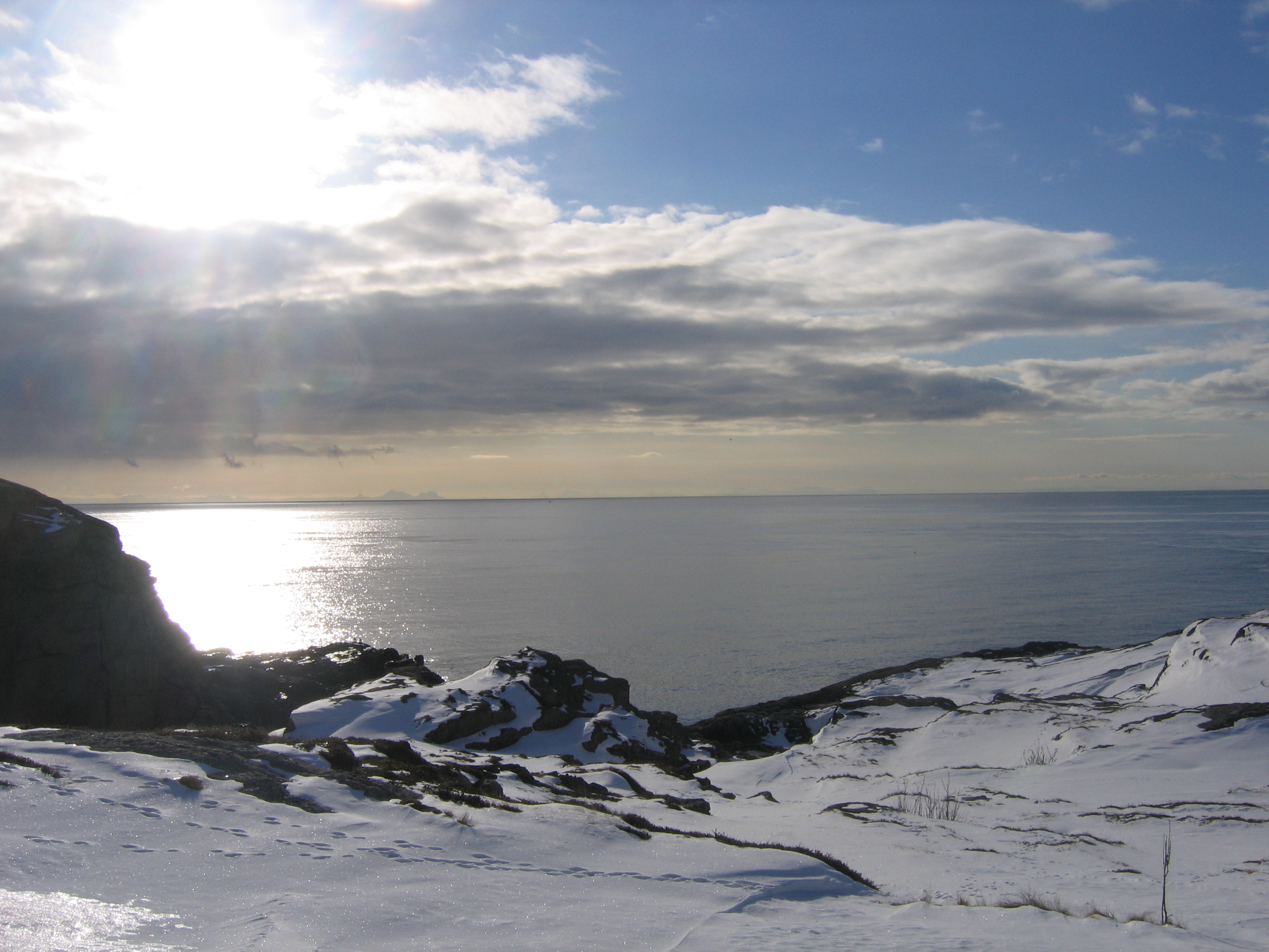
In front, snow-topped rocks rising several hundred meter above me. To my back, the sea, in this place going south, so going straight ahead would land one somewhere in the south of Nordland. To the right of the sea are rocky islands rising out of the sea. Lofotodden. Værøy. The islands south of Røst: Vedøya, Storfjellet. Here is the Maelstrom, the biggest system of tidal currents in the world. To the left the mainland on the other side of Vestfjorden. All white and rocky, as if the mountains are not 1000 but 4000 meter high. And this all under the nearly deafening sound of hundreds of gulls flying overhead.
I forget the cold and try to make some pictures. I fail because my battery won't work. I walk around and let the world impress me. I am all alone. Nobody is awake. If I stay with my back toward the village, I could be alone in the world. But the village is just a few hundred meters away. This is worth the journey. More than worth it. It would be worth a journey all the way from the Netherlands. A once in a lifetime experience. And marvellous weather.
At 9:00 I take the long bus ride back. The first part, until Leknes, I haven't seen in daylight yet. The weather is changing, and it starts snowing horizontally. Strong westerly wind. In Svolvær I have to wait a couple of hours. It's not comfortable outside in this stormy, snowy weather. Svolvær reminds me of Åndalsnes. Hurtigruten stops here. Later in my life I will travel with Hurtigruten. For now, this is too expensive for me. The bus from Narvik arrives, the same bus that will go back to Narvik an hour and a half later. I ask the bus driver if there is some waiting room. There isn't, unfortunately. Just an unheated glass hall between two buildings. I sit there and read some. The bus driver is sleeping. At 15:00 I enter the bus again. Back the same route. Svolvær. Lødingen. The Tjeldsund bridge. Evenes. I ask the bus driver if we will be in time for the train back to Sweden. The bus arrives at 19:20. The train leaves at 19:22. It's rather tricky. It seems to me that he drives faster because of me asking this, but I'm still nervous. In the end we arrive at 19:17 at the railway station, and I make it into the train.
The train is nearly empty. It is dark outside. I am alone in my compartment. Outside, there is nothing visible at all. At one point I don't know if we are traveling or not. I don't have a clue where we are. It might as well be a metro line. After Lofoten and Hinnøya, this is really the end of the world again. Beyond the end of the world. Kiruna is the end of the world from the other side. In Narvik it starts again. Now I am in between. I am nowhere.
More pictures at my picasaweb albums.
1 comment:
top [url=http://www.c-online-casino.co.uk/]free casino bonus[/url] brake the latest [url=http://www.casinolasvegass.com/]free casino[/url] autonomous no deposit hand-out at the best [url=http://www.baywatchcasino.com/]casino
[/url].
Post a Comment